Smarter fire modelling could strengthen resilience across New Zealand
23 February 2026 | News
As fire risk intensifies across New Zealand, heightened awareness of climate-driven weather extremes is prompting a growing call for tools to help predict the likelihood, frequency and severity of forest fires. As housing expands into once-rural, fire-prone areas, and fire threatens people, homes, primary production and biodiversity, developing more accurate and informed fire management strategies is increasingly urgent.
To support this need, new research suggests that advanced modelling used successfully overseas could be applied in New Zealand to better predict fire refugia—areas of land that remain unburnt during a fire. Understanding where these refugia occur can help guide fire management, land-use planning and environmental protection in a future expected to face more frequent extreme fire events.
Te Whare Wānaka o Aoraki Lincoln University’s Dr Helen de Klerk co-authored Predicting persistent forest fire refugia using machine learning models with topographic, microclimate and surface wind variables, published in the International Journal of Geo-Information. In the study, modelling was used to develop maps identifying fire refugia across large areas of forest in the Southern Cape and Tsitsikamma region of South Africa.
“When landscapes burn, it's important to understand which areas may remain unburnt in the event of a fire as they protect flora that can regenerate ecosystems and provide safe havens for animals and insects,” says Dr de Klerk.
She notes that the landscapes examined in the South African research share significant similarities with those in the South Island of New Zealand, making the approach highly relevant and an exciting option for use in fire management here.
“Both regions have mountains with steep slopes and undulating foothills,” Dr de Klerk explains. “These varied landscapes are exposed to changing wind directions, and their orientations can shift rapidly over short distances. The result is complex wind behaviour that is often difficult to predict. With mountain ranges positioned close to coastlines in both countries, the interactions between terrain and sea wind movements add another layer of complexity.”
The modelling used in the study improves the understanding of wind movements around mountains and identifies the likely locations of wind channels – critical information for predicting fire behaviour. Key variables include hill and mountain slope steepness, whether the slope faces the sun or is shaded, wind direction and air temperature.
Having recently presented the research at a local fire forum, Dr de Klerk is encouraged by the interest from New Zealand’s fire and land management communities. Because this type of modelling has not yet been applied here, the potential benefits are substantial.
“This tool could help predict local wind movements during fires, improving our understanding of how fires spread. It could also help identify natural firebreaks, defensible spaces for backburning or safer zones for firefighting operations.
“Prioritising where to place resources is essential during fast-moving fire events, and there is strong interest in identifying fire refugia so they can be incorporated into fire break strategies.”
Dr de Klerk says adopting this modelling approach would be a valuable step for New Zealand.
“Research of this kind would help protect not only communities and ecosystems but also the country’s economy. Our food and fibre industries rely on productive land, so would benefit greatly from better prediction tools, which ultimately, would lead to greater resilience.”
For media enquiries, please contact media@lincoln.ac.nz
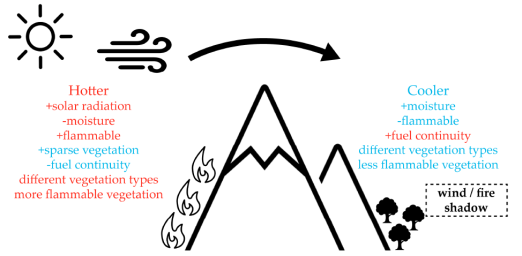
The graphic shows the relationships among aspect, temperature, moisture balance, vegetation flammability, and predominant fire wind direction, and their association with fire risk.


